

Evolution of Transportation and Its Impact on Mississippi River Towns
The first week of June I presented with colleagues the impact of the Mississippi River on the adjacent river communities for the virtual Preserve Iowa Summit. My portion of the presentation was on the evolution of transportation and its unique effect on river towns not seen further inland. My colleague and historic architect Michelle Cunliffe focused unique architectural features seen in communities along the Mississippi River and other major bodies of water. For instance, building entrances often fronted the waterfront when steamboat travel was prominent, but were redesigned once vehicular traffic took hold to face the street. Ryan Peterson, a landscape architect in my office, wrapped up the presentation with a look at the redesign planned for Dubuque, Iowa's Central Avenue Corridor.
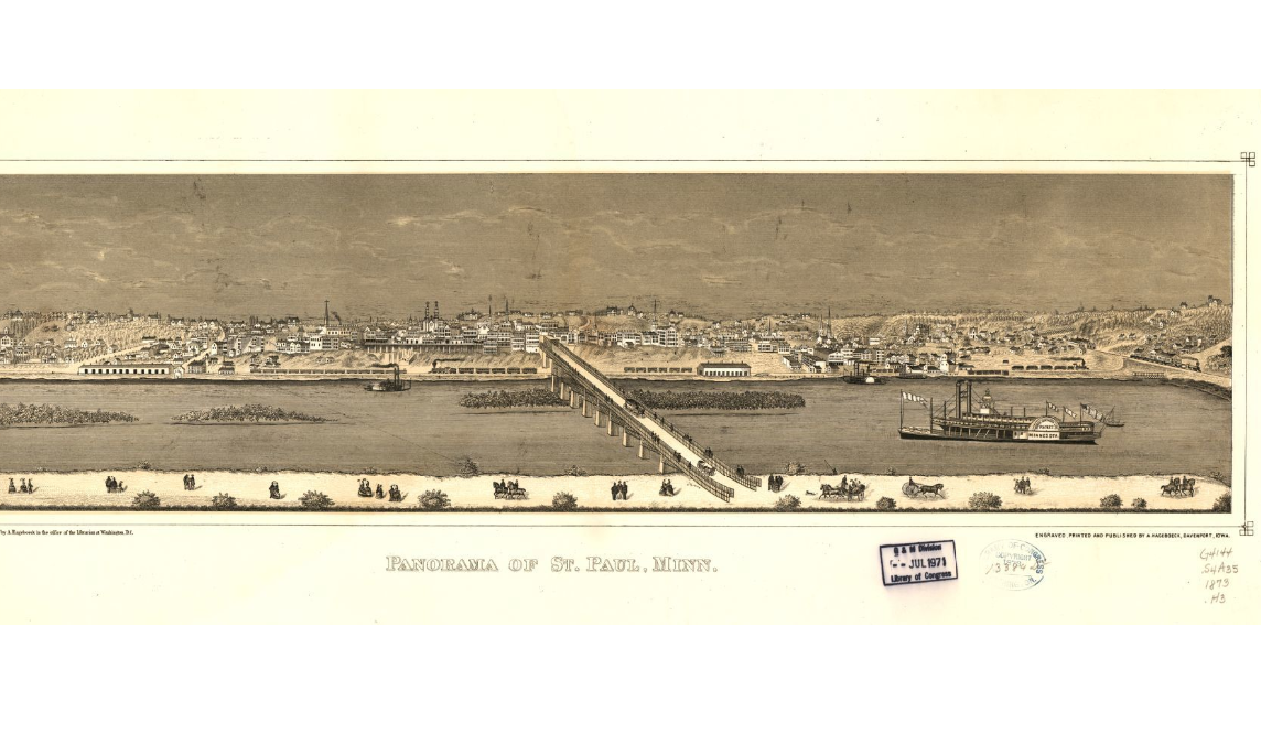
St. Paul, MN panorama from 1873 showing layers of transportation including the stagecoach, steamboat, and railroad (Source: Library of Congress)
Researching the history of the Mississippi River and more specifically the communities along the river in Iowa was incredibly fascinating. While I knew the river was one of the longest in the U.S. (2nd) I did not realize it was one of the world's major systems in terms of its diversity, size, and productivity. Its watershed is the fourth largest in the world and the river runs a total of 2,350 miles. I've been to its headwaters in Itasca State Park up in Minnesota several times and have seen various sections of the river at the Twin Cities, in Iowa and Missouri and as far south as New Orleans. While its believed by some geologists to be 200 million years old it wasn't formally discovered until 1541. Hernando DeSoto is the first recorded person to have visited the river, but its potential as an economic resource was not exploited until the French fur traders came through centuries later. The U.S. first gained control of river and its resources with the 1803 Louisiana Purchase.
The first towns in the Midwest all started along rivers like the Mississippi. In Iowa, all the first communities were established on the river in the 1830s . This was because the river provided transportation and connections to the rest of the U.S as well as a way for the early fur traders and miners to get their goods to market. These towns remained the largest and most prosperous communities for several decades, until the railroad network was built, lessening the importance of the river and thus the river towns. In Iowa for example, the largest town was Burlington located in the north end of the state on the Mississippi River. By 1880, the most populous cities were all still river towns, with only Des Moines not located on the Mississippi River. The river also impacted the physical design of the adjacent towns. The street grid would often shift to follow the river but keep the streets at a right angle. This resulted in triangle spaces that often were reflected in flatiron or sheared wall designs for the structures on those lots. The shifting grid also created unique framed vistas of prominent structures that occupied the lots at the street bends.


Linear town layout of Muscatine, IA as a result of its early development on the Mississippi River (Source: Library of Congress)
In the early days, the shipment of goods was done either by overland stagecoach or on rivers using a flatboat or keel boat with poles and oars. Starting in 1823 with the launch of the first steamboat on the Mississippi River the primitive transportation methods sharply declined. The impact of the steamboat on communities was largely related to land use and economics. Under steam power, people and goods could be transported upstream far more quickly and in greater numbers and quantities than on boats with sails, oars or poles. Waterfront property became valuable for its access resulting in a linear town layout that maximized access to the water. Towns like Muscatine and Keokuk, Iowa were only a few blocks deep, but followed the river for many blocks. The steamboat continued to serve an important purpose until about the 1940s when the diesel fueled tugboat replaced it as the superior vessel. Today the remaining steamboats are used mostly for tourism.
The days of river transportation were numbered. In 1831 the first railroad was built in Baltimore, Maryland. It was viewed as a silly, newfangled invention, but it quickly became clear the railroad would become an important method of travel. Expansion of American commerce was no longer limited by the routes nature provided, but could be distributed among a large network of tracks across the nation. Though railway construction halted during the Civil War, laying more tracks quickly picked back up by the late 1860’s. The success of the railroad lasted for many decades but with the invention of the automobile and the good roads movement in the early 1900s which created better paved and maintained highways, the railroad began to decline. By the 1960s passenger service was discontinued in most towns and several lines were discontinued.
The impact of the railroad on river towns was different than most of the inland communities because the river towns were already well established by the time the railroad came through. Inland towns dried up if the railroad was routed around them, but not for the river towns which already had good access to transportation through the Mississippi. Unlike the river, the railroad’s alignment did not affect the street grid, but actually just cut through it. This disregard for the street grid resulted in unique building designs shaped like a rhombus or featuring angled walls.

Impact of the railroad on buildings and the street grid in Davenport, Iowa as shown in the red boxes (Source: Library of Congress)
The first automobile was showcased at the Linn County Fair in 1899. In 1905 there were 799 ‘horseless carriages’ in Iowa. By 1915 Iowa had the most automobiles registered per capita in the nation at 147, 078. By 1927 there was one automobile per 3.3 persons. With the rise of the automobile, a town’s location on the river was no longer key to development and survival. The automobile allowed a person to travel anywhere, not just on the preset path of the river or railroad. The automobile did not have a great impact on the layout of communities which were already well established by this point, but it did eventually impact the location of businesses. With the construction of highway systems, shipping on the Mississippi River slowly dwindled, lessening the importance of locating industry on the riverfront. Businesses shifted inward and began locating along highways instead of fronting the river, leaving large vacant tracts of land.
This evolution of transportation systems has had an interesting impact on the role the Mississippi River played in the river towns. It began as a resource that was exploited for its transportation access. It then became a liability when the automobile arrived and the industries once lining the shore moved away to be closer to the highway system leaving behind years of pollution and dilapidated buildings. It is now returning to an asset as communities re-imagine the riverfront as a recreation and tourism booster. This trend can be seen in communities all across the nation.
One of the most prominent examples on the Mississippi River is in Minneapolis where early in their history the shore was lined on both sides with massive flour mills that harnessed the rivers power to run their operations. When Rochester, NY became the flour capital, the Minneapolis mills closed, leaving the buildings to fall into disrepair and the river to become a source of blight and crime. In the 1990s the city began cleaning up the river front, creating access points and restoring and preserving many of the old mill sites. Today it’s not only an incredible recreational amenity for residents, but is a large tourist destination for the city.
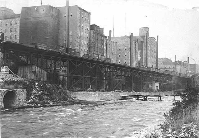
Minneapolis riverfront before the decline of the four milling industry (Source: minneapolisparkhistory.com)
The decisions we make about transportation options today have great impacts as we can see from reviewing the evolution over 200 years of various modes of transportation. At its core, transportation gets us from point A to point B, ideally in the quickest and easiest way possible. It is not so simple to just develop a system that achieves those metrics since we know decisions concerning transportation have great impacts on the physical development of communities and the well being of their residents. An example of this is in Dubuque, Iowa where the railroad and subsequent highway cuts off the residents from easy access to the riverfront and severs the grid of downtown. As we move forward over the next 200 years of transportation enhancements we need to plan for and design a system with positive and lasting impacts.


